Now that we have learned about the climate of Texas and how Texas might react to climate change in the future, let’s turn our attention towards water. Where is the water in Texas? To begin, let’s start with the global water cycle.

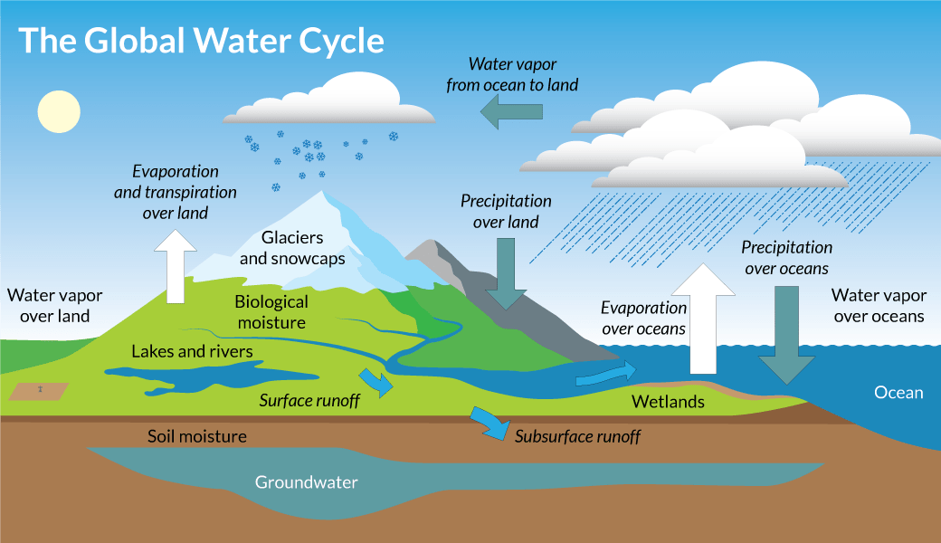
The global water cycle is truly a cycle with no end in sight. Once water is consumed, that water eventually makes it back to the cycle. You may remember learning about evaporation, condensation, and precipitation; however, the global water cycle encompasses much more. To learn more about the global water cycle, visit our Water Cycle Interactive. Once you’ve explored the interactive answer the questions below.
Click on “Precipitation Over Land,” and watch the short clip. When does precipitation occur?
When water vapor in the atmosphere is too heavy
Incorrect.
When atmospheric water vapor condenses and is pulled back to Earth by gravity
Correct.
Click on “Lakes and Rivers,” and watch the short clip. What are the waters at the surface a combination of?
Precipitation and groundwater baseflow
Correct.
Water discharged from aquifers
Incorrect.
Click on “Evaporation and Transpiration Over Land,” and watch the short clip. What is transpiration?
The process of evaporation from lakes and rivers
Incorrect.
The process of evaporation from Earth's plants
Correct.
Click on “Groundwater,” and watch the short clip. Where does the water generally go that is discharged from aquifers?
To springs, or as baseflow to streams and rivers
Correct.
Water is not discharged from the aquifer
Incorrect.
Water Resources In Texas
Water resources for human consumption can be broken down into two broad categories:
- Surface water: Surface water includes water from rivers, lakes, streams, wetlands, and oceans that occupy the Earth’s surface
- Ground water: Ground water includes water sources situated below the surface, such as groundwater aquifers that may discharge into nearby streams or contribute to surface water baseflow.
Surface Water in Texas
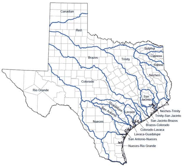
The state of Texas encompasses over thousands of streams, hundreds of reservoirs, and fifteen major rivers that all cumulate to over 190,000 miles of surface water landscape throughout the state.1Texas Parks & Wildlife. (n.d.). Texas River Guide. TPWD. https://tpwd.texas.gov/landwater/water/habitats/rivers These flowing waterways eventually drain into estuaries, ending up either in the Rio Grande River, the Texas Gulf Coast, or the Mississippi River. Water from all of these systems end up in the Gulf of Mexico. The number of waterways can be attributable to the diverse climates that span the state. In addition to these naturally flowing streams and rivers, the state constructed a number of reservoirs in the middle of the twentieth-century for flood control and water resource availability following prolonged droughts. According to the Water Development Board, reservoirs contribute to more than 50% of the available surface water.2Texas Water Development Board. (n.d.). Texas Lakes & Reservoirs. View all Texas Lakes & Reservoirs | Texas Water Development Board. https://www.twdb.texas.gov/surfacewater/rivers/reservoirs/index.asp
The fifteen major rivers in Texas include:3Maps of World. (n.d.). Texas Rivers Map, Rivers in Texas. https://www.mapsofworld.com/usa/states/texas/texas-river-map.html
- Canadian River
- Red River
- Brazos River
- Sulphur River
- Trinity River
- Sabine River
- Neches River
- San Jacinto River
- Guadalupe River
- Lavaca River
- San Antonio River
- Colorado River
- Nueces River
- Rio Grande River
- Cypress River

Groundwater in Texas
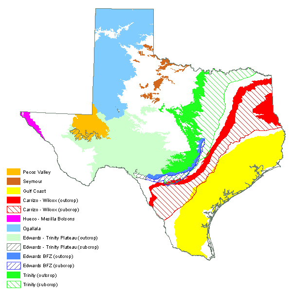
Abundant aquifers are located beneath over three-fourths of the state; these aquifers have contributed to water use purposes for centuries. Over half of the state’s total water usage, measured at roughly 16-million acre feet annually (325,851 gallons = 1 acre foot), comes from groundwater sources consisting of nine major and twenty-two minor aquifers aquifers underlying Texas. An aquifer outcrop is the area where the aquifer is exposed at the ground surface. This exposure is the principal recharge zone for the aquifer. Long-term water supply for irrigation purposes in Texas is highly dependent on groundwater and groundwater recharge, especially in arid/semi-arid regions, such as West Texas and the Texas Panhandle.
The nine major aquifers in Texas include:4Texas Almanac. (2019, October 4). Major Aquifers of Texas. Aquifers of Texas | Texas Almanac. https://texasalmanac.com/topics/environment/aquifers-texas
- Pecos Valley Aquifer
- Seymour Aquifer
- Gulf Coast Aquifer
- Carrizo-Wilcox Aquifer
- Hueco-Mesilla Bolsons Aquifer
- Ogallala Aquifer
- Edwards-Trinity Plateau Aquifer
- Edwards (Balcones Fault Zone) Aquifer
- Trinity Aquifer

Imaged Credits: TOP Energy Training; maps from the Texas Water Development Board
Image Credits
- Major rivers map of Texas: Texas Water Development Board (TWDB)
- Major Aquifers of Texas: Texas Water Development Board (TWDB)